| |
The Cordillera del Cóndor, composed of flat-topped sandstone mountains, forms part of the international border between Ecuador and Peru.
|

| |
Cerro Ijiach Naint in the Cordillera del Cóndor region. The team from Missouri Botanical Garden and the National Herbarium of Ecuador were the first biologists to visit this area and scale the summit, in March 2001, with help from Shuar assistants from the nearby village of Tinkimints. Several plant species new to science were found on the summit at 2000 m elevation.
|

| |
A view of the upper Cenepa River valley, in Peru, looking east from the crest of the Cordillera del Cóndor within Ecuador. The palm at left is Dictyocaryum lamarckianum, which also occurs on the eastern slopes of the main Andean chain. |

| |
Looking west from the summit ridge of the Cordillera del Cóndor: the lower slopes of the valleys on the Ecuadorian side have mostly been deforested.
|

| |
The vegetation on the summit of the Cordillera del Cóndor is a dense "dwarf forest" -- small trees and shrubs, most with thick leathery leaves.
|

| |
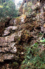
Many unusual plants grow on the vertical sandstone cliffs of the Cordillera del Cóndor. At lower elevations, the rock is made of limestone, with yet different plants.
|

| |
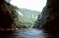
Nangaritza River canyon with sheer vertical walls formed of sandstone.
|

| |
The "black" water that drains from the sandstone rocks of the Cordillera del Cóndor is actually the color of strong tea -- from the tannins and humic acids in the water leached from the surrounding vegetation.
|

| |
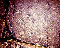
Fossil ammonites in sedimentary rocks near the Nangaritza River. These extinct marine molluscs lived during the Cretaceous period, more than 65 million years ago, when this region was part of the Pacific Ocean.
|

| |
Plant collectors in the Cordillera del Cóndor, December 2000: Ecuadorian students from the National Herbarium and Shuar ethnobotanists, accompanied by soldiers from a nearby Ecuadorian army post.
|


